Currently viewing the tag: "Pangea"

Richard D. L. Fulton

Earthquakes are not common in Maryland, but they are also not rare, most being so insignificant that they are not even detectable by any of the state’s residents whenever they do occur.

But why does the state even have earthquakes, and why are they not like the West Coast versions? The answer lies in the geological history of the state, a history which it shares with the other Mid-Atlantic States.

The more constant and dramatic earthquakes that occur on the west coast are the result of the ongoing collision of the western edge of the North American continental plate colliding with the edge of the Pacific continental plate. Like an irresistible force colliding with an immovable object, the result of the two plates grinding against one another has produced, not only innumerable earthquakes, but volcanism as well, in the form of active volcanoes.

The earthquakes in Maryland are the product of a similar force, but one that occurred more than 200 million years ago when a supercontinent, called Pangea, began to break up. In this case, the African continental plate, which had adhered itself to the eastern edge of the North American plate, began to break-off and drift away from North America.

The environment at the time was very much like that which is occurring along the west coast of the United States today, only possibly even more violent. As the African continent ripped itself apart from North America, the cataclysmic earthquakes that resulted created deep fractures beneath the surface, which are now called faults (successive series of connected faults are called fault lines, some of which span multiple states.)

Faults, basically being cracks, generally consist of two parts (sides), one side (called a hanging wall), which “hangs” over the opposing side (called a foot wall). Over the course of tens of millions of years, these structures have become weakened from the forces exerted by overlying layers of rock, and the effects of groundwater attacking the structural integrity of the rocks.

Eventually, these opposing fault walls will slip or collapse with such force that they would then generate shock waves which would quickly work their way to the surface, resulting in earthquakes.

To demonstrate the difference between the earthquakes produced by the collision of the Western and Pacific plates, California experiences, on average, 35 measurable earthquakes a day. As a result of the process that produces earthquakes in Maryland, Maryland has experienced only 70 earthquakes since 1758.

As of the date of the writing of this article, the following Maryland communities experienced earthquakes: Spencerville two weeks ago (1.8 magnitude); Rockville six months ago (1.8 magnitude); Sykesville one year ago (1.8 magnitude); Woodlawn two years ago (1.8 magnitude); Highland two years ago 2.1 magnitude). Woodlawn three years ago (one 1.6 magnitude and one 2.6); and Sykesville six years ago (1.5 magnitude). These are low-level magnitude earthquakes with little if any resulting damage.

The first earthquake recorded to have occurred in Maryland took place on April 25, 1758, south of Annapolis. There existed no means whatsoever of measuring the magnitude at that time, so the power of the earthquake remained unknown. According to WTOP News, in Maryland’s extensive earthquake history, the quake had reportedly lasted 30 seconds, and had emitted what was described as “weird noises.”

While Maryland was subjected by earthquakes generated within the state, some of the larger earthquakes which have impacted Maryland were triggered outside of the state.

One of the largest earthquakes to hit Maryland in recent times actually originated in Mineral, Virginia, on August 23, 2011. The quake was rated as having attained a 5.8 magnitude.

The United States Geological Survey summed up the impact as follows: “Moderately heavy damage occurred in a rural region of Louisa County, southwest of Mineral. Widespread light to moderate damage occurred from central Virginia to southern Maryland, including the District of Columbia area. Minor damage (was) reported in parts of Delaware, southeastern Pennsylvania and southern New Jersey. Very strongly felt at Boston, Bumpass, Kents Store, Louisa, Mineral, Rhoadesville and Sumerduck. Felt strongly in much of central Virginia and southern Maryland. Felt throughout the eastern US from central Georgia to central Maine and west to Detroit, Michigan and Chicago, Illinois. Felt in many parts of southeastern Canada from Montreal to Windsor.”

Mainly a nuisance quake, which left pictures hung on walls askew and rattling some dishes, one of the quake’s greatest impacts was inflicted in the cellphone network, mainly the result of so many people simultaneously trying to make phone calls, in order to figure out what was going on.

“Significant network volume caused some customers to lose service for about 20 minutes.” Melanie Ortel, a Verizon spokeswoman, told the Easton, Maryland, Record Observer,” adding, “Everything returned to normal, once the tremors ended.”

Typical of what Marylanders experienced in the 2011 earthquake was reflected in the account given to The Baltimore Sun, by Loch Raven Village resident Renate Shelley and her husband, and published in the newspaper’s August 24, 2011, edition, in which the couple stated that they were sitting in their SUV watching their dog play while at Gunpowder State Park when the earthquake struck, and their car, in which they were parked at that time, began moving.

“We felt the car go left, and then right, and then back and forth, but we weren’t driving,” Renate Shelley told the newspaper, adding that her husband, who had been “snoozing,” asked, “What the Hell was that?”

On the lighter side, The Baltimore Sun reported on August 31, 2011, “Less than an hour after the final rumbles… a T-shirt emblazoned with “I Survived the Virginia Earthquake’ was selling for $16.00 on eBay.”

The seller was identified as 29-year-old Catonsville resident Tony Uzupus, who had designed the shirt “within five hours of the quake,” and then posted the shirts on the auction site, reportedly telling The Sun, “I figured I would strike while the iron was hot.”

By August 29, the newspaper reported, Uzupus had sold several dozen shirts.

The most recent earthquake experienced in Maryland did not originate in Maryland, as per the 2011 Virginia quake, and occurred on April 5, 2024.

The 2024 quake—actually two back-to-back quakes—originated in New Jersey. The first quake was a 4.8 magnitude quake and was triggered around 10:23 a.m. in Lebanon, New Jersey, while the second quake was a 4.0 magnitude quake and was triggered around 6:11 a.m. in Gladstone, New Jersey,

The dual earthquakes, felt from New York to Maryland, were more of nuisance quakes than damaging-inflicting ones, although a few quake-related injuries and some structural damages had been reported.

Projecting or predicting when a Maryland earthquake is about to occur is nearly impossible, since, unlike the West Coast earthquakes, there is little-tono advance warning, mainly due to the difference between Maryland geology, and that of the West Coast.

Other than employing earthquake resilient construction in erecting new buildings, the only real defense a resident may have is to simply keep a battery-operated radio on hand and several flashlights, as one would do in order to deal with any power -grid threatening emergency, and to stay off the phones. Individuals placing calls in mass during the 2011 quake caused the communications grid to crash.

Richard D. L. Fulton

A great many people in North Frederick County are likely unaware as they go about their daily business or endeavors, that beneath their feet rests the vestiges of an ancient continent that, like the legendary Atlantis, was ultimately destroyed and lost to time.

This particular Atlantis existed during a period of time presently classified as being Late Triassic in age, which occurred some 220 million years ago when one sole continent existed… a continent, dubbed Pangea by geologists.

During this period of time, Pangea was in its “death throws” and was in the process of breaking up, due to the movement of the continental plates beneath it. That breakup led to the formation of a number of subcontinents, resulting in the end of Pangea around 200 million years ago.

But, in Rocky Ridge, one can still walk the ancient shoreline of one of Pangea’s great lakes that existed before its demise and even explore the lake bottom of this huge lake, dubbed Lake Lockatong. 

At the height of this lake’s existence, Lake Lockatong sprawled from Rocky Ridge through Pennsylvania, New Jersey, and into New York State. Some geologists believe that this great lake covered an area equivalent to the presently existing Lake Tanganyika in Africa, at some 20,000 total miles in size. 

Over millions of years, the sediments that had been deposited at the bottom of this lake in Rocky Ridge, as well as those of the associated mud flats, solidified into shale, and today provide a “window” into what times were like in Rocky Ridge when it was part of Pangea.

The most dominant vertebrate that abounded on the ancient mudflats of Rocky Ride was, without a doubt, a foot-long lizard called Rhynchosauroides, an animal that is believed to have been an ancient ancestor of the tuatara, which only exists today in New Zealand. 
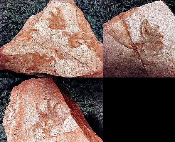
Hundreds of tracks of this lizard have been found in the Rocky Ridge mudflats, along with rare body impressions made when the lizards rested on the mud in shallow water. 

Another rarer cat-sized reptile that wandered upon the mud flats is classified as dicynodonts, a group thought to have been extinct long before the Rocky Ridge mudflats were formed. It is generally believed that mammals evolved from this group of reptiles.

The Rocky Ridge Rhynchosauroides shared their environment with millepedes (also known today as thousand leggers) and prehistoric crickets and beetles, whose trackways lie scattered among the layers containing Rhynchosauroides tracks. One specimen was found revealing the body impression of a Rhynchosauroides surrounded by fossil cricket tracks!

The shale from the lake bottom found in Rocky Ridge revealed complete fossil fish, fish scales, coprolites (fossil excretion), fragmented bones, and the track of an as-yet unidentified aquatic reptile.  There was plenty of food for these creatures in the lake, as their remains have been found with a multitude of freshwater clam shrimp, snails, and clams.

One particular Rocky Ridge site revealed that an immense conifer forest had existed at the time in proximity to the lake shore, and its branches, complete with leaves, were found in an eddy that had apparently formed off the lake and which was also loaded with freshwater clam shrimp.

Dinosaur tracks have yet to be found in the Late Triassic Rocky Ridge deposits, but dinosaur tracks were collected in the 1800s in a flagstone (rock intended to be used in walkways) that had been quarried only a few minutes away, outside of Emmitsburg. 

A geologist—now retired—identified a layer of green shale in Rocky Ridge that would be the layer most likely to produce dinosaur tracks, but that layer has yet to be excavated.

Because every fossil recovered from the Late Triassic Rocky Ridge sites is new to Maryland and/or new to science, access to one of the richest sites is now presently restricted and is located on private property.